Trip Facts
- Activities: Trekking and Sight trip
- Trekking Type: Camping Trek
- Best Season: Sept - Dec / Feb - May
- Total Duration: 25 Days
- Trek Duration: 22 Days
- Min Group Size: 5+ pax
- Max. Height: 5, 360 m. / 17,585 FT
- Transportation: Drive in / Drive Out
- Trek Start From: Kathmandu
- Trek End To: Kathmandu
Detail Itinerary of Dhaulagiri Circuit Trekking
- Day 01: Arrive Kathmandu at (1’365m. 4’478ft.)
It is a panoramic thrill flying into Kathmandu on a clear day. The views of snow-capped mountain peaks sprawling down below you are almost ecstatic, beginning a whole chain of memorable experiences that stay with you for a long, long time. A representative and driver will meet you at the international airport in kathmandu and escort you to your hotel. - Day 02: City sightseeing in Kathmandu Valley
Kathmandu is the historical and cultural heart of Nepal and has been a popular destination for tourists ever since Nepal opened its doors to visitors. The city presents a wonderful mix of Hinduism, Tibetan Buddhism and Western influence in the Valley. Patan and Bhaktapur, its two major neighboring cities bear immense historical, cultural and religious significances. - Day 03: Fly or drive to Pokhara at (840m. 2'755ft.) about 30 minutes fly and 7 hours bus journeys
From Kathmandu, we take a half an hour scenic flight to Pokhara or we drive for about 7 hours to Pokhara (200 km) from kathmandu. You can spend the later part of the day exploring Pokhara. Set amidst the spectacular backdrop of the Annapurna, Dhaulagiri and Machhapuchhre, the must visit sites of Pokhara include the Phewa Lake, Davis fall, Mahendra cave, the famous Seti Gorge, the beautiful temple of Bindabasini and Pokhara Mountain Museum. - Day 04: Drive to Beni Bazaar at ( 850m. 2'788ft.) about 4 hours drive, where starting point of our trekking.
After breakfast, we drive from Pokhara to Beni, from where our trek commences. The drive should take around 4 hours and it offers good scenic views. Beni is at the confluence of the Myagdi Khola and the Kali Gandaki Camp. Being the districts headquarter, Beni has a police check post where our trekking permits will be examined. - Day 05: Beni Bazaar - Singa Bazar at ( 853m. 2'798ft.) about 6 hours Trek
From Beni, we leave the Kali Gandaki and head west along the north bank of the Myagdi Khola through the village of Beni Mangalghat to Singa Bazar. - Day 06: Singa Bazaar – Takum at (932m.3'057ft.) about 6 hours Trek
Today, from Singa Bazar we trek along the trail to Takum. - Day 07: Takum - Muri at (1'850m.6'069ft.) about 7 hours Trek
Today, after crossing a river, we head north to Phedi. As we leave, the trail starts climbing. We come across many switch-backs until we arrive at the ridge. The trail again climbs steeply up to Muri at 1850 m. moving up along the trail, we trek to Sibang and Mattim. From here, continuing up an incline to the snout of a ridge, we descend to the Gatti Khola and reach Phalai Gaon 1810m. We then cross the Dhara Khola to again emerge on the west bank of the Myagdi Khola. After climbing a ridge, we finally reach the large Magar village of Muri. From Muri, we get amazing views of Mt. Dhaulagiri and other surrounding mountains. - Day 08: Muri – Bagar chhap at (2'080 m. 6'824ft.) about 7 hours Trek
After a short descend, we cross a stream and continue through terraced fields. Climbing a ridge, we reach the pass from where we can see Mt. Ghustung South 6465 m. descending to the Myagdi Khola and trekking along its West Bank to the village of Naura, we climb for a short while. Traversing a grassy hill and climbing a steep slope with switch-backs, we then descend through a forest and terraced fields to reach Bagar chhap at 2080m. Place where we camp. - Day 09: Bagar chhap - Dovan at (2’250m. 7'381ft.) abou7 hours Trek
Leaving Bagar chhap, we continue along the trail. We descend through terraced fields to a small ridge and then passing through forest to reach Jyardan. After the settlement, a high winding path crosses a rocky area and then descends before climbing up again to Lipshe where there is a single hut. The trail continues through a forest to Lapche Kharka and then climbs to Doban. Today the path is quite difficult and sometimes we might need to use ropes. - Day 10: Dovan - Italian Base Camp at (3’800m. 12'467ft.) about 7 hours Trek
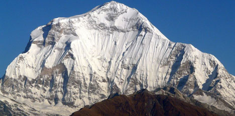
Crossing a wooden bridge out of Dobang, the trail ascends a forested area. Passing through the beautiful forest, we rapidly gain altitude as mountains surround us. After crossing the Myagdi Khola, we later cross a stream to reach Choriban Khola. We continue along the trail (which is not very well defined) to the terminal moraine of the Chhonbarban Glacier and enter the glacier from the right. Tukche Peak 6837 m. becomes visible straight on at the far end, while the impressive north flank of Dhaulagiri I 8’167 m. dominates the skyline to our right. After a short while we reach the Italian Base Camp 3’660 m. To the west are the peaks of Dhaulagiri II 7’751m, Dhaulagiri III 7’715 m and Dhaulagiri V 7’618 m. - Day 11: At Italian Base Camp for acclimatization
- Day 12: Italian Base camp - Midway Camp at (4’500m. 14'763ft.) about 7 hours Trek
Today, we trek along the trail to the Midway Camp. This trail is a little tough, so probably we might need to use a rope in a couple of tricky spots. The surroundings here are spectacular, with magnificent views of the beautiful snow-capped peaks. - Day 13: At midway Camp for acclimatization
- Day 14: Midway Camp - Classic Base Camp at (5’000m. 16'404ft.) about 8 hours Trek.
After proper acclimatization, today we climb steadily to the rough and chilling but spectacular Classic Base Camp at 5’000m. This is a vantage point from where we get amazing views of the Dhaulagiri Ranges.
Day 15: At Classic Base Camp for acclimatization - Day 16: Classic Base camp - below Dhampus pass at (5’200m. 17'060ft.) about 8 hours Trek
After proper acclimatization, we climb two terraced hills before entering an ablation valley. We then climb to the French Col 5’100 m from where we can see Mukti Himal at 6’328 m., Tashi Kang 6’386 m and Sita Chuchura 6’611 m. To the south is Tukche Peak 6’920 m. and beyond is the massive peak of Dhaulagiri I. From French Pass we continue along the trail towards Dhampus Pass at 5’200m. We camp below Dhampus Pass. - Day 17: Dhampus - Dhampus Pass at (5'200)m. 17'060ft.) – Alubari at (4’545m.14'911ft.) about 8 hours Trek
Today, after climbing over the 5200m Dhampus Pass, we traverse avalanche prone slopes and then descend steeply to Yak Kharka. From Yak Kharka, we continue along the trail to reach Alubari. - Day 18: Alubari - Marpha at (2’665m. 8'743ft.) about 7 hours Trek
We now begin the descent down the dramatic Kali Gandaki Gorge. After passing through Jharkot and Khingar, villages with typical Tibetan architecture, we follow the valley floor most of the way to Jomsom. The Jomsom is sprawled along both banks of the Kali Gandaki and from here we get fine views of the Nilgiri peaks. We continue down to Marpha, a delightful Thakali village, with a well-planned drainage system. Its narrow alleys and passageways provide welcome shelter from the strong winds of the Kali Gandaki Gorge. The Marpha is particularly well known for its apples, apple cider and apple, apricot and peach rakshi. - Day 19: Marpha - Lete at (2’470m. 8'103ft.) about 7 hours Trek
Now, we continue descending the Kali Gandaki Gorge to Tukuche, a Thakali village with a large gompa. Beyond Tukuche we walk along the west bank of the Kali Gandaki towards Larjung. Here, as in many of the villages in this area, narrow alleyways and tunnels connect houses with enclosed courtyards, providing protection against the wind blowing up the valley. We make our way through pine, juniper and cypress forests to Kalopani, enjoying fine views of Annapurna I and Fang. We then reach Lete, which lies just twenty minutes beyond Kalopani. - Day 20: Lete – Tatopani (Hot spring) at (1’160m. 3'805ft.) about 7 hours Trek
Our trail descends steeply through forests to Ghasa, the last Thakali village and the southern-most limit of Tibetan Buddhism. We enter the steepest and narrowest part of the gorge shortly after Ghasa. At the hamlet of Rupse chhahara (a magnificent waterfall tumbles down beside the trail). Continuing on, we come to Dana, a Magar village from where the massive peak of Annapurna South still can be seen across the valley. The trail then descends to Tatopani (Hot spring) where we can have apple pie and bathe in the hot springs. - Day 21: Tatopani - Ghorepani at (2’850m. 9'350ft.) about 8 hours Trek
A short distance downstream from Tatopani, we cross the river on a large suspension bridge and leave the Kali Gandaki behind. After passing through the villages of Sikha and Chitre, we climb through the forest to Deurali, at 2’834m pass from where we can get excellent views of Dhaulagiri, Nilgiri, Annapurna I, Annapurna South, and Hiunchuli. Just 10 minutes beyond the pass is the village of Ghorepani. Ghorepani literally means "horse water" and is a welcome watering spot for the packs of mules, which ply the route between Pokhara and Jomsom. - Day 22: Ghorepani – Tikhedhunga at (1'650m. 5'313ft.) about 7 hours Trek
Overlooking Ghorepani is Poon Hill at (3’210m. 10'531ft.) about 45 minutes-long pre-dawn ascent gives us the opportunity to see the fascinating views of the Annapurnas and Dhaulagiri glowing in the morning sun. After breakfast, we begin the long descent to Tikhedhunga passing through magnificent oak and rhododendron forests. From the village of Ulleri, a long steep stone staircase seems to go on forever before eventually reaching Tikhedhunga. - Day 23: Tikhedhunga – Birethanti about 4 hours Trek and – Pokhara about 2 hours bus journeys
Leaving Tikhedhunga and it’s A more gradual descent then brings us to Birethanti, from where it is a short distance to the road and our transport that takes us to Pokhara. - Day 24: Fly or drive to Kathmandu at (1'365m. 4'478ft.) about 30 minutes fly and 7 hours bus journeys
From pokhara, we take a half an hour scenic flight to kathmandu or we drive for about 7 hours (200 km) from pokhara. You can spend the later part of the day exploring in kathmandu. - Day 25: Departure Kathmandu
Our support teams will take you to the international airport for your flight back home.